Expeditionary team retraces Silk Road
The joint expedition from Fudan University and the Dunhuang Academy of China conducted a seven-day investigation of the part of the Silk Road that extends from Lop Nor to the Altun Mountains.
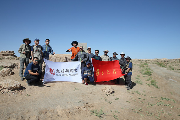
On June 27, a joint expedition from Fudan University and the Dunhuang Academy of China returned to Dunhuang after their seven-day investigation of the part of the Silk Road that extends from Lop Nor to the Altun Mountains. The team traversed places such as Gansu Province, the Dunhuang area, Ruoqiang County and the Kazak Autonomous County of Aksay, totaling nearly 2,000 kilometers.
Rediscovery
The path from Dunhuang to Loulan has been obscure throughout history. Official archives have failed to provide clues. To make matters worse, various maps of the Silk Road only show a straight line between the two locations, while the actual path is anything but straightforward. In the late 19th century and early 20th century, Swedish explorer Sven Hedin and British archaeologist Marc Aurel Stein were the last scholars to systematically investigate the road. They conducted fieldwork along the traditional path and left valuable maps and records.
Hou Yangfang, dean of the Fudan-Ruinan “Belt and Road” Studies Center and director of Fudan-Gansu Synergetic Development Institute of the Silk Road Economic Belt, led the investigation of the Perfectly Normal Paths and the Jade Gate Paths.
Historical records about this part of the Silk Road are vague, and place names changed throughout time, causing more confusion. Fieldwork is necessary to answer why ancient people chose the paths for trade and other economic activities.
On the afternoon of June 27, Hou and his team arrived at the Perfectly Normal Pass and completed the south path of the Silk Road. The team started from Dunhuang, moving westward all the way through the Perfectly Normal Pass, the Jade Gate Pass, Loulan, the Pamirs and finally arrived at Da Rou Zhi and Anxi. Since the investigation and recovery of the Silk Road began in April 2013, the team has traversed a distance of 2,000 kilometers and climbed more than 10 crucial mountains from the Perfectly Normal Pass to the turn of the Panj River.
Zhang Yuanlin, a research fellow at the Dunhuang Academy China, said that fieldwork complements literary archives, confirming the characteristics of the ancient cities of Loulan and Milan and the locations of ancient cities, such as Yixun and Yuni.
Trade
When thinking of the Silk Road, people usually picture a group of camels climbing giant sand dunes. However, Hou said that although it is a romantic image, it would not be a common sight, because deserts were often avoided when choosing paths.
Instead, the paths in the high-altitude mountain valleys were favored despite their twisting routes. The only exception along the road was the Sanlong dune belt, but it is easy to pass because the height of the dunes was relatively low, reaching 10 to 12 meters high.
On the ancient Silk Road, water was the most important resource. It determined the course of the route. Springs, rivers and lakes were important landmarks. All the paths chosen were linked by oases with abundant water reserves. Beacon towers and post houses were built along water sources. Besides providing drinking water for humans and animals, these rivers and lakes were also important channels for waterborne transport.
Lop Nor, once known as “the sea of Puchang,” covered an area of more than 10,000 square kilometers, larger than modern archaeologists expected. The Tarim River, the Peacock River, the Qarqan River and the Miran River flowed into Lop Nor, constituting a giant water transportation network. The team also found an ancient wharf at the Tuyin Site, which was first discovered and named by Huang Wenbi (1893-1966) in 1930. Hou argued that the economy of Tuyin at that time resembled the economy of Shanghai today because it was located at the entrance of the Peacock River to Lop Nor.
Hardship
Fieldwork on the Silk Road was painstaking. It focused on sparsely populated regions of the Gobi Desert and mountain areas where communication signals could be cut off by complicated and tough geographical conditions. The team members suffered from scorching sun, high temperatures, wind gusts and a bumpy journey. They camped outside at times and ate simply. Fresh vegetables and fruits were luxuries. They encountered a huge sand storm that lasted for five hours after departing from Loulan. However, the team persevered despite hardship. Hou and his team will continue their expedition in important areas, such as the Gilgit District and Purushapura in Pakistan, in order to confirm the real paths walked by an army in the Tang Dynasty (618-907) on their military expeditions to conquer the Western Regions.
Zhang Chunhai is a reporter at the Chinese Social Sciences Today.